About EarthAI Site

EarthAI Site provides an end to end software platform so teams can remotely view their global investments in real-time with our satellite imagery, and make better decisions using our data and analytics. The platform helps renewable energy investors reduce costs throughout a project's lifecycle, collaborate, and improve ROI.

Manage Your Sites

Monitor your sites and/or portfolio companies remotely, saving time and resources. Gain visibility into your target locations or competitive projects.

Make Informed Decisions

Leverage our many datasets and satellite partnerships to access the most recent and accurate information, eliminating costs and uncertainty.

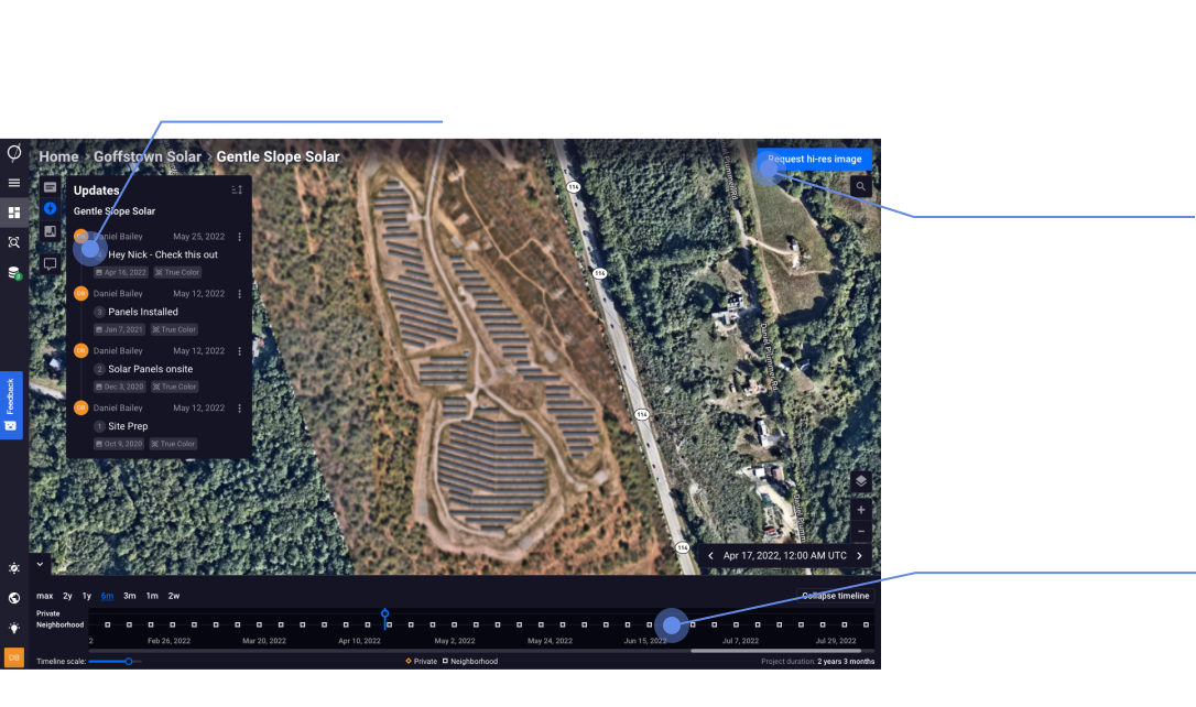
Improve Visibility and Collaboration

Quickly get internal teams and external investorsor portfolio companies on the same page. Compare investments, site location, and technology using real-time aerial imagery and platform analytics.

Data and Analytics Over Time

Visualize change over time with customized alerts, historical data, and side-by-side imagery analysis. Blend your data to create tailored analytics dashboards to accelerate your work.

About Astraea

Astraea is a satellite intelligence company that helps clients view the Earth with real-time imagery, combined with advanced analytics, to make better decisions about their business. By eliminating common barriers to processing imagery, Astraea is enabling individuals and organizations to access, analyze, and unlock actionable insights from petabytes of Earth-observing data at a fraction of the cost and complexity previously required. We work with multiple industries combating climate change, from renewable energy, carbon finance, real estate, conservation, and sustainable agriculture.

Allow your teams, across the globe, to view each of your investments in real-time and share analysis

Advanced computer vision algorithms detect changesin ground conditions and notify you by text or email
Through our collaboration- centric platform, you and your team can annotateand share comments.
Seamlessly export and send reports, summarizing your data analysis and streamlining project updates.

Use Cases for Renewable Energy Investors

Project Screening

Accelerate site selection processes and reduce in-person visits leveraging our satellite imagery and real estate database. Filter parcels that are most relevant to your investment criteria and analyze lease opportunities.

Construction

Monitor your assets in real time, track construction progress, and gain insight into competitive projects being built nearby. Eliminate interconnection queue ambiguity and run accurate project completion probabilities.

Operations & Maintenance

Decrease O&M costs and improve ROI for each project using remote sensing to target maintenance at the most affected areas. Replace legacy inspection costs with satellite imagery at a fraction of the cost. Quickly detect solar performance, vegetation encroachment, or PV module string anomalies using aerial thermal imaging to prevent unnecessary power losses.

Stakeholder Collaboration

Leverage our platform to quickly get internal teams and external investors on the same page. Create reports and analyses that can be shared across teams in an organization. View and compare investments, site location, and technology using aerial imagery, intuitive software, and customized dashboards.

Renewable Energy